Location: 9:20 pm PDT, Lat: 26 deg 45.372′ N, Long: 118 deg 39.199′ W, Course 181 deg M, Speed: 7.0 k, Wind: N 16.0 k, Swell: NW 4′ … see our map.
What can I say other than we are doing well. Yet another day on the ocean and this evening we are doing a little bit of surfing as the swells roll under the boat to push us along to our destination.
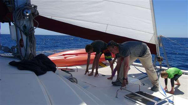 This afternoon after everyone was feeling a bit seasick from some choppy water, Jaeden and I decided to go to the front of the boat and get some exercise. We set up a tablet computer on the deck and stood on the trampoline of “Far & Away” to go through a grueling 1 hour P90X routine. I have to say that it sure added a new challenge to the routine by having a floor surface that kept moving every time we jumped into the air. It was a bit tricky trying to keep proper balance and a few times I took a spill as the ground was not where I thought it would be. Being cooped up on a boat however it was great to get some exercise and the seasick feeling left as we were half of the time in the air jumping and doing other exercises. It took Jaeden’s mind off of being sick. So far he is the only one to have lost a meal overboard (yesterday).
Jaeden made a great dinner and some homemade cinnamon buns for desert today. Yes we are baking up a storm in our galley, complete with freshly ground spelt flour. The true way to keep a crew this size happy is to feed them well.
I checked in as I do every evening to the Pacific Seafarer’s Amateur Radio Net to report our position. This is a Ham radio call in group that lets all vessels that are underway, report their positions and sea conditions so you should now see where we are along our route. I have been able to experiment a bit with the technical features of my radio equipment as well. I have it hooked up to my laptop so that we can send and receive emails as well as the weather forecasts and reports. I’m still trying to figure out a few of the forecasting features but we are picking up on it. I am also in regular contact with Karol back at home who monitors a radio frequency that I can easily reach him on in the evenings.
Here is the course that we have plotted based on Jimmy Cornell’s World Routes book. We head South before crossing the doldrums and then slide a bit west across the equator before completing the l shaped curve to the Marquesas. Here are the GPS plots we have made for our route although we may go slightly West of these points depending on weather and sea conditions. Anyone with better experience or ideas please let us know.
1 San Diego – 32° 37′ N, 117° 14′ W
2 20° N, 120° W
3 10° N, 122° W
4 5° N, 123° W
5 0°, 125° W
6 5.33° S, 130° W
7 139.2° S, 9.9° W
—–
At 20/04/2013 2:41 AM (utc) our position was 26°49.56’N 118°38.23’W
We are very pleased to get all you updates and enjoy your children’s actions and posts. We just had a wonderful Sunday in our little branch today. May the Lord Bless You and Keep You Safe.
Luv
Gwen and Barry Pratt
Every time I read your blog all I can think is “Wow!!” and “Those are one group of gutsy people”